
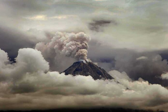
Indonesia’s Mount Semeru pounded its summit with a rapid-fire chain of eruptions over 13 hours, pushing ash up to 900 meters and forcing fresh warnings to stay clear of deadly flow paths.
Story Snapshot
- Officials logged repeated eruptions from just after midnight to early afternoon.
- Ash plumes rose 300–900 meters above the summit during the sequence.
- Monitors reported seismic bursts tied to individual blasts.
- Authorities kept strict no-go zones near the crater and Besuk Kobokan River.
What Happened And When
Monitors at Indonesia’s Center for Volcanology and Geological Hazard Mitigation tracked a burst of activity at Mount Semeru on October 13. Reports described at least 10 eruptions between 12:09 a.m. and 1:11 p.m. local time, with bursts clustered before dawn and restarting through late morning into early afternoon. Other outlets, citing the same agency and radio logs, listed nine eruptions through 11:00 a.m., which likely reflects a reporting cutoff rather than a different trend. The takeaway is simple: Semeru was busy, and the clock did not matter to the mountain.
Ash columns rose between 300 and 900 meters above the summit during the run. State media placed the top plume height at 900 meters. Observers also reported ash drifting with the wind after several blasts. Those numbers put the day’s eruptive energy in the small-to-moderate range for this volcano, yet they confirm real explosions and real ash in the sky. This is not a rumor mill event. It is measured activity with clear heights and times pulled from operational logs.
How Monitors Knew It Was Real
Seismic instruments at the observatory recorded the eruptions as sharp signals. The early afternoon blast at 1:11 p.m. showed a maximum amplitude of about 15 millimeters and lasted roughly 88 seconds, according to reporting tied to the official system. A late-morning event near 10:37 a.m. clocked in stronger and longer, with a reported amplitude of 22 millimeters over 137 seconds. That pairing of ash heights with timed seismic signatures is the gold standard for confirming short, discrete eruptions in near real time.
Officials did not change the alert level during the sequence, which remained at Level III on Indonesia’s four-step scale, but they repeated blunt instructions. People were told to avoid activity within 13 kilometers of the summit along the Besuk Kobokan drainage, where pyroclastic flows and mudflows can race without warning. Separate guidance kept a five-kilometer exclusion around the crater due to the risk from heavy, hot rocks. These rules may feel harsh on a calm afternoon. They look wise when a hot flow rounds a bend faster than a motorcycle can move.
Why The Count Differs, And Why It Matters Less Than You Think
News outlets did not match on the final tally. Some listed nine eruptions through late morning. Others said at least 10 when adding the 1:11 p.m. event. The difference likely comes from update windows, not confusion. Volcanoes do not erupt on newsroom deadlines. For the person deciding whether to cross a closed river valley, the split between nine and 10 does not change the stakes. One bad flow on the wrong day is what kills, not the headline score.
🌋 Volcanic Ash Advisory: Semeru
Mount Semeru, Indonesia: eruption reported at 14:46 UTC on 8 October 2026. Ash reached 15,000 feet and was moving east at 5 knots. Advisory issued at 18:20 UTC; ground reports indicate ongoing eruptions.More info: https://t.co/oFT17RBMZe
— Early Warning (@VolcanoEWS) October 8, 2026
Semeru has erupted for decades, often with daily blasts that paint the summit gray and then fade from view. The Smithsonian’s Global Volcanism Program notes nearly continuous activity since 1967, with lava, ash, and flow hazards woven into local life. The mountain also has a darker side. In December 2021, a major event sent ash high into the sky and pushed hot flows into communities, causing heavy losses. That history is why a “routine” day still earns firm rules and clear lanes.
How To Read The Signals Like A Pro
Two questions guide risk at a volcano like this: where will heavy stuff go, and what turns rain into concrete? The heaviest things are pyroclastic flows and falling rocks near the summit. That is why the five-kilometer crater zone stays closed. The valleys hold the next threat. The Besuk Kobokan River is a chute for hot debris and for mudflows when rain mixes with ash. That is why the 13-kilometer corridor stays off-limits when activity picks up. The map, not the mood, should drive your choices.
Bottom Line For People On The Ground
The October 13 run showed a busy, restless Semeru producing repeated blasts, measurable ash columns, and tight seismic pops. The science fits the advice: keep out of the crater zone and far from the Besuk Kobokan channel until monitors say the risk has eased. The count will fade. The valleys will not move. Respect the lanes, watch official updates, and treat short ash bursts as the warning signs they are, not as background noise earned by years of smaller shows.
Sources:
insiderpaper.com, megapolitan.antaranews.com, malaymail.com, databoks.katadata.co.id
© ournationnews.com 2026. All rights reserved.